

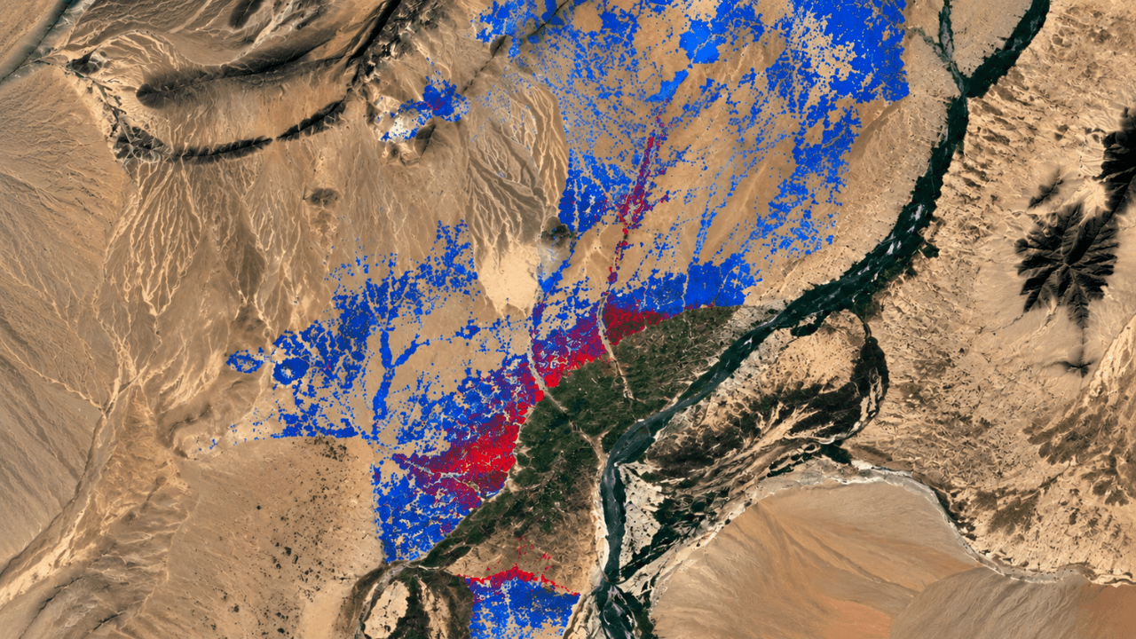
Kuva Space, a Finnish space-technology company developing hyperspectral Earth-observation satellites and AI-powered intelligence solutions, has completed a pilot with a key European security stakeholder demonstrating how hyperspectral satellite data can improve the monitoring of illicit crops at regional scale.
The study focused on opium poppy cultivation in Afghanistan and combined Kuva Space’s Hyperfield imagery with Sentinel-2 data and AI-based classification.
I spoke to Olli Eloranta, Data Scientist at Kuva Space, to learn more.
Shifts in illicit opium production
Illicit crops such as opium poppy can be difficult to distinguish from legal crops using conventional satellite imagery alone, especially when illicit crops are grown among other similar-looking crops.
The geography of illicit opium production is shifting rapidly. According to the UN’s 2026 World Drug Report, Afghanistan’s opium production remains dramatically below pre-ban levels, while poppy cultivation in Myanmar increased 17 per cent in 2025, making it the world’s largest opium producer.
As cultivation shifts between regions, authorities need monitoring systems that can scale across large territories where physical access may be limited. Kuva Space’s approach addresses that challenge by using hyperspectral satellites and AI to identify where more detailed investigation is most likely to be valuable.
In the pilot, combining data from Kuva Space’s hyperspectral Hyperfield-1 satellites with Copernicus Sentinel-2, the EU’s conventional multispectral Earth-observation mission, reduced false positives compared with Sentinel-2 alone.
Across the analysed area in Helmand Province, the system identified 248,889 agricultural fields and flagged 8,835 as likely poppy fields.
Mapping nearly 249,000 fields from space
Kuva Space’s proprietary Hyperfield-1 satellites collected 363 hyperspectral images between January and June 2026, providing repeated observations across key agricultural regions during the growing season. In total, the imagery covered 648,450 km², showing the potential to apply the approach across large, hard-to-access areas rather than only small test sites.
Because precise maps of Afghanistan’s agricultural fields were not available, Kuva Space used a separate model to identify field boundaries. It fine-tuned the model using 10-metre-resolution Sentinel-2 data to account for the country’s small fields and surrounding desert terrain.
The model identified the agricultural fields that provided the spatial basis for classification. Accurately identifying those individual parcels was itself a challenge. Eloranta explained:
“It outperformed publicly available boundaries and let us tie each detection to an individual parcel, with geolocation accuracy averaging 21.75 metres – under one Hyperfield pixel.”
Kuva Space’s in-house foundation model then analysed the delineated parcels for the spectral signatures associated with opium poppy. Rather than classifying individual pixels, the system makes predictions at the parcel level, providing a more interpretable and operationally useful result.
The model learned to identify poppy signatures from a relatively small set of expert annotations, rather than mapping the field boundaries itself.
To distinguish poppies from legal crops with similar spectral signatures, Kuva Space combines hyperspectral imagery with AI and multi-temporal data.
“Hyperspectral sensors measure light across many narrow spectral bands, allowing our AI models to detect subtle vegetation differences linked to chlorophyll, water content, and pigmentation. In the pilot, we separated poppy from visually similar crops,” detailed Eloranta.
The company also analyses imagery captured at different points in time to help verify the distinctive growth and harvesting patterns associated with poppy cultivation.
Why reducing false positives matters
Kuva Space’s combined model achieved 75 per cent accuracy versus 71 per cent with Sentinel-2 alone. According to Eloranta, however, the headline number understates the practical impact.
“The gain came specifically from reducing false positives, and at this scale that matters enormously. We screened nearly 249,000 fields, so even a few points of improvement remove a large number of wrong leads.“
Because the whole point is to direct costly, very-high-resolution imagery and analyst time to the fields most likely to warrant investigation, cutting false positives directly improves the cost and scalability of monitoring.
"And this is a first-generation result — we're targeting ≥90 per cent accuracy through more in-situ ground-truth data, higher-quality hyperspectral data from our second-generation Hyperfield-2 satellites, and integration of other modalities such as SAR, weather data and DEMs.”
While the results broadly align with recent UNODC reporting at an aggregate level, Kuva Space says verifying individual fields will require more in-situ ground-truth data.
“At the aggregate level, the cultivation patterns we produced broadly align with recent UNODC reporting, our primary reference.
Field-by-field verification is the natural next step, and it’s where more in-situ ground truth comes in.”
This distinction is important: the 8,835 fields represent those classified by the model as likely poppy fields, rather than 8,835 individually verified instances of poppy cultivation.
The predictions are intended to help authorities prioritise areas for closer inspection rather than treating every agricultural field as an equal verification target.
Can growers fool hyperspectral satellites?
I was curious whether growers could deliberately disguise crops to fool hyperspectral detection.
Eloranta admits, “It's a real challenge, but our approach is built to handle it.”
“Because hyperspectral sensors collect data across hundreds of narrow bands, we can often detect subtle differences in material composition that give crops away even when they look alike to the eye.
We combine this with multi-temporal and phenological knowledge – growth cycles, harvest timing – to strengthen identification, and where needed, we can further check detections against higher-resolution signals, whether through super-resolution or hand-picked, very-high-resolution validation.”
From pilot to operational monitoring
Kuva Space trained its in-house foundation model on the entire Hyperfield data archive of 1.2 million image patches, studied a limited reference area, and then applied it across a much larger region
The company is already extending its poppy-detection work to Myanmar, where additional information such as geographic location and altitude can be incorporated to sharpen identification.
“Satellite monitoring has traditionally forced a trade-off between covering very large areas and seeing enough detail to identify what is actually growing there. Hyperfield data and in-house AI-powered models start to close that gap,” said Jarkko Antila, CEO of Kuva Space.
“By detecting differences in vegetation that conventional imagery misses, we can screen entire regions and focus the most expensive analysis on a much smaller set of high-probability areas.
That changes both the economics and the scalability of illicit crop monitoring.”
Eloranta says the company plans to expand the range of crops its models can identify in response to customer demand. The same approach could potentially be adapted to other opium-producing regions, as well as crops such as coca or cannabis.
“We'll continue adding crops, both legal and illegal, based on market pull – i.e., the crops our customers most need to monitor.”


Would you like to write the first comment?
Login to post comments