

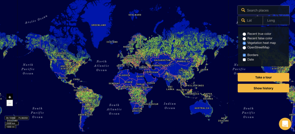
Finland-based startup Terramonitor has launched the first version of its mapping platform that provides often-updated satellite imagery of the Earth. Based on the open-source imagery by the European Space Agency (ESA), the platform is free to use for research purposes, while commercial users would have to pay at least €275 per month for unlimited usage.
Terramonitor says it uses artificial intelligence algorithms to piece its maps together from some 100 million images from ESA and update them as the fresh photos are published. The solution is aimed first of all at organisations working in the areas of forestry, infrastructure, agriculture, and environmental research.
The satellite imagery provided by Terramonitor is available in the web browser, but can also be integrated with its clients' geographic information systems (GIS) of choice. In addition to the most recent photos from the orbit, the system can show historical data going as far back as the summer of 2015.
Having access to the satellite imagery doesn't always mean you can see how any part of the planet's surface looked on any day. Although the delay between the images landing at the ESA servers and becoming available at Terramonitor is just several hours, quite a few areas on the map are comprised of photos shot last month.
“The images are taken twice a week, but as you can imagine, most of the images are usually covered by clouds and are not usable, or eye-friendly,” Terramonitor told tech.eu. “The Terramonitor AI algorithm detects and removes these images to provide high-quality and comprehensive mosaics.”
This is also the main difference between Terramonitor and similar services, according to the startup. Most of the competing imagery providers would send across the photos with metadata comments like “The Netherlands, 80 percent cloud,” leaving it to the end user to look for images where anything meaningful can be seen.
Terramonitor has a team of seven people and is going to join ESA's Business Incubation Centre later this year. The one-year incubation program is there “to work with and inspire entrepreneurs to turn space-connected business ideas into commercial start-up companies.” The company has also raised an undisclosed funding round from a VC firm.


Would you like to write the first comment?
Login to post comments